The EMB is used to compensate for the functions of wetlands that are unavoidably lost as a result of both private and public projects.
Purchase process
Permit Requirements
The purchase process begins with the regulating agencies' permitting process and the determination that the impacted wetlands are eligible to be offset by our mitigation bank (see service territory and types of mitigation credits below). Based upon permit application information and the functional assessment (see below) of the impacted wetlands, the agencies will determine the number of mitigation credits that will need to be purchased.
Purchase and Sales Agreement
Once the number of credits is determined, a purchase and sales agreement will be executed. There are two options for payment of the purchase price. First, payment maybe made in full at the time the agreement is executed. Second, a deposit can be paid on the execution of the agreement and the balance paid in 90 days.
Functional Assessment
The Wetland Assessment Technique for Environmental Review (WATER) has been created to provide a tool for assessing the functional value of an impacted wetland. This assessment technique consists of two separate and distinct procedures. The first, a Functional Evaluation, is purely ecological in nature. The second is a Value Evaluation that reflects the impacted site's suitability, as measured by criteria rating the social significance provided by the area in question.
Instructions to complete a WATER score along with the functional evaluation and site suitability evaluation forms can be downloaded here.
Wetland Assessment Technique for Environmental Review Score Sheet
Mitigation Bank Wetland Function Evaluation & Impact Site Evaluation Matrix
Wetland Assessment Technique For Environmental Review Manual
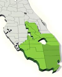
The Mitigation Service Area (MSA) is located within Miami-Dade and Broward Counties, and Palm Beach County south and west of a line commencing at the Atlantic Ocean and proceeding westward along the southern Palm Beach County line to U.S. Highway 1, then proceeding north along U.S. Highway 1 to State Road 794 (Yamato Road), then proceeding westward along Yamato Road to State Road 809 (Military Trail), then proceeding northward along Military Trail to State Road 80 (Southern Boulevard), then proceeding due west to the western Palm Beach County line, with the exception of those lands contained within the southwest portion of the C-51 west drainage basin. Non-linear projects may use the Bank to provide compensatory mitigation for wetland impacts that will occur wholly or partially within the MSA. Linear projects may use the Bank to provide compensatory mitigation for wetland impacts located within the jurisdictional boundary of the South Florida Water Management District ("SFWMD"). Authorization will be granted on a case-by-case basis upon sufficient demonstration of ecological compatibility and / or "like kind replacement." Linear projects include, but are not limited to, electric transmission lines or distribution lines, and substations as defined in Section 403.503(12), Florida Statutes: roadways, natural gas, liquid energy sources, petroleum, water, sewer and other pipelines; fiber optic, cable and other communication facilities; and railways. Exceptions to this Mitigation Service Area may be considered by the permitting agency on a case-by-case basis. |
Types of Mitigation Credits
- Freshwater Herbaceous
- Freshwater Forested
- Saltwater/Coastal
Contact us for additional information.