
To save time and avoid confusion during an emergency, there are a few pieces of information that will help you and your family be prepared. Print out the Important Emergency Information Worksheet and keep it where you will be able to find it when it counts.
- In which subarea do you live? Use the map to find the subarea in which you live. It is not likely that everyone within 10 miles of the Turkey Point Nuclear Power Plant would be affected during an emergency. The area affected would depend on weather conditions, such as wind speed, direction and the severity of the incident. Knowing your subarea will help you identify how best to protect yourself and your family.
- Where is your reception center? Reception centers are available to provide food, shelter and communications during an emergency.
- What is your best evacuation route? Evacuation routes are outlined on the map and detailed below. Familiarizing yourself with the evacuation route now will help reduce stress during an emergency. In the event of an evacuation, emergency public transportation will be provided to those that need assistance. Contact your local emergency management agency to pre-register.
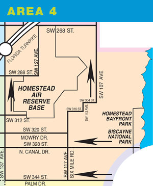
Area 4 is defined as the area within the following boundary: SW 280th Street west from the coast to SW 107th Avenue. SW 107th Avenue north to SW 268th Street (Hainlin Mill Drive). SW 268th Street west to SW 137th Avenue. SW 137th Avenue south to Palm Drive (SW 344th Street). SW 344th Street east to the area 2 boundary. Follows area 2 boundary to the shore and follows the shore north to SW 280th Street.
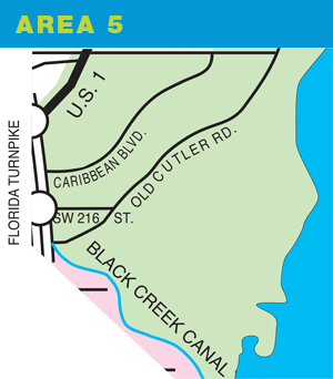
Area 5 is defined as the area within the following boundary: Eureka Drive (SW 184th Street) west from the coast to S Dixie Highway (U.S. Highway 1). U.S. Highway 1 south to the Florida Turnpike. Florida Turnpike south to Black Creek Canal. Follows Black Creek Canal south to the shore. Follows the shoreline north to Eureka Drive.
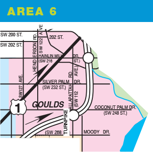
Area 6 is defined as the area within the following boundary: West on Caribbean Boulevard (SW 200th Street) from the intersection with U.S. Highway 1 and the Florida Turnpike to SW 122nd Avenue. South on SW 122nd Avenue to SW 204th Street. West on SW 204th Street to SW 127th Avenue. South on SW 127th Avenue to Hainlin Mill Drive (SW 216th Street). West on SW 216th Street to SW 137th Avenue. South on SW 137th Avenue to Moody Drive (SW 268th Street). East on Moody Drive to SW 107th Avenue. South on SW 107th Avenue to SW 280th Street. East on SW 280th Street to the shore. Follows the shoreline north to Black Creek Canal. Follows Black Creek Canal north to the Florida Turnpike. Florida Turnpike north to the intersection with U.S. Highway 1 just north of Caribbean Boulevard.
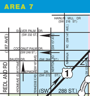
Area 7 is defined as the area within the following boundary: Hainlin Mill Drive (SW 216th Street) west from the intersection with SW 137th Avenue to Naranja Road (SW 147th Avenue). Naranja Road south to Silver Palm Drive (SW 232nd Street). Silver Palm Drive west to Newton Road (SW 157th Avenue). Newton Road south to Coconut Palm Drive (SW 248th Street). Coconut Palm Drive west to Tennessee Road (SW 167th Avenue). Tennessee Road south to Epmore Drive (SW 272nd Street). Epmore Drive west to Krome Avenue (SW 177th Street). Krome Avenue south to Biscayne Drive (SW 288th Street). Biscayne Drive east to SW 137th Avenue. SW 137th Avenue north to intersection with Hainlin Mill Drive.
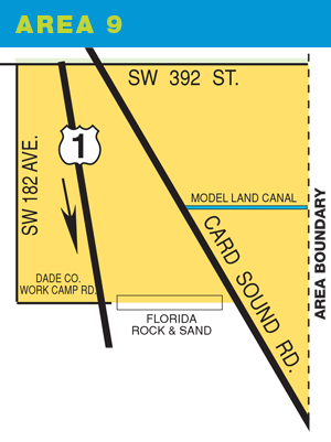
Area 9 is defined as the area within the following boundary: SW 392nd Street west from the intersection with SW 137th Avenue to SW 182nd Avenue. SW 182nd Avenue south to Dade County Work Camp Road. Work Camp Road east to Card Sound Road (road physically ends at U.S. Highway 1). Card Sound Road south to SW 137th Avenue. SW 137th Avenue north to intersection with SW 392nd Street.
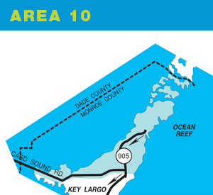
Area 10 consists of the Ocean Reef Community and Card Sound Road residents and visitors.
Area 10 Evacuation Route:
All traffic should evacuate south using State Road 905 and US 1. The shelter will be located at the Key Largo Elementary School, MM 105.
Emergency Transportation Assistance
If you have no transportation, call one of the following numbers: Ocean Reef Public Safety (305) 367-2222, Monroe County Social Services (305) 853-1923.